
Open Data Cube
Open Data Cube
The Open Data Cube (ODC) is a community of people and organisations building capability for working with earth observation data. At the core, the ODC is a software library and set of command line tools. And keeping the core together we have a group of organisations collaborating on strategy and who may maintain specific implementations of the ODC.
The objective of the ODC is to increase the impact of satellite data by providing an open and freely accessible exploitation tool, and to foster a community to develop, sustain, and grow the breadth and depth of applications.
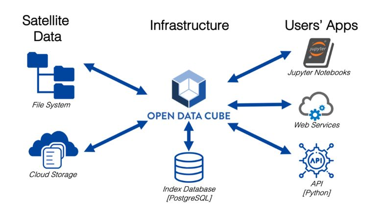
At a technical level, an implementation of the ODC is made up of three things: data, an index and software:
Data is usually file based, either in local directories of GeoTIFFs or NetCDF files, but data can be anything that GDAL can read, including Cloud Optimised GeoTIFFs stored on AWS’ S3.
For the Index, the ODC uses PostgreSQL as a database to store a list of Products (a specific data type, like Landsat 8 Analysis Ready Data) and Datasets (a single instance of a Product, for example, a single Landsat 8 scene). The index enables a user to ask for data at a time and location, without needing to know specifically where the required files are stored and how to access them.
The Software at the core of the ODC is a Python library that enables a user to index data (add records to the Index), to ingest data (optimise indexed data for performance), to query data (returning data in a standard data format) and a wide range of other functions related to managing data.

Core Features
storing, processing and analyzing large collections of earth observation data
Gridding and contouring functions
Details
Website: https://www.opendatacube.org
Licence: Apache License Version 2
Software Version: 1.8.9
Supported Platforms: GNU/Linux, Mac OSX, MS Windows
API Interfaces: Command line
Support: https://www.opendatacube.org/faq
