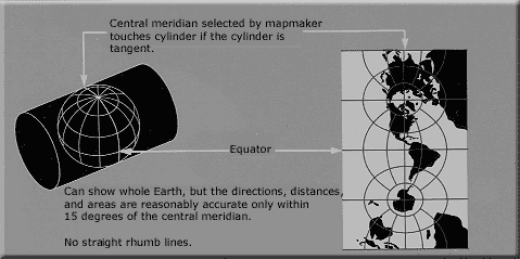

The group of MetaCRS projects provide libraries of methods to transform between different coordinate reference systems. A geographic coordinate reference systems allows all points on the earth to be described as set of coordinates (such as latitude, longitude and elevation). Different systems are used to represent the 3 dimensional earth on a flat, 2 dimensional map.
The MetaCRS libraries are included in other projects and some are also available via a command line interface.
The sub-projects that make up MetaCRS include:
The projects typically use coordinate system definitions as defined by the European Petroleum Survey Group (EPSG) and defined in Well Known Text (WKT) format.
Website: http://trac.osgeo.org/proj/
Licence: X/MIT style Open Source license
Software Version: 4.7.0
Supported Platforms: Windows, Linux, Mac
API Interfaces: C, C++, Python, Java, Ruby
Website: http://proj4js.org
Licence: X/MIT style Open Source license
Software Version: 1.1.0
Supported Platforms: Windows, Linux, Mac
API Interfaces: JavaScript
Website: http://trac.osgeo.org/csmap/
Licence: custom
Software Version: 13.0
Supported Platforms: Windows, Linux, Mac
API Interfaces: C, C++
Website: http://trac.osgeo.org/geotiff/
Licence: X/MIT style Open Source license
Software Version: 1.4.0
Website: http://trac.osgeo.org/proj4j/
Licence: Apache License, Version 2.0
Software Version:
Supported Platforms: Windows, Linux, Mac
API Interfaces: Java