

GeoStyler Quickstart
This Quickstart describes the basic steps required to start working with GeoStyler: installing GeoStyler and adding a first UI component to your react application.
A complete beginner tutorial can be found on localhost/geostyler.
GeoStyler makes it easy to style geodata in any web page. The UI is independent from any styling format and should be usable for e.g. OpenLayer or SLD.
Contents
Installing GeoStyler
In order to use GeoStyler, you need to have node.js installed on your system.
Instructions on how to install node.js can be found on the
node.js homepage.
It is recommended to install GeoStyler for each project separately. This sections describes the required steps.
The most simple way to install GeoStyler is to use npm that comes with the
node.js installation. Simply run following command from your project root:
npm i geostyler
Please make sure that all peer dependencies are installed in the specified versions:
npm i react react-dom antd ol
Don’t forget to install the parsers you want to use:
npm i geostyler-sld-parser
Integrate GeoStyler
Import the GeoStyler Style component into your application as follows:
import { Style } from 'geostyler';
The Style component provides a variety of styling functionality.
After importing, you can use it in your render method like this:
<Style
    compact={true}
/>
The Style component should now be visible in the browser.
Integrate geostyler-sld-parser
To edit an existing SLD via GeoStyler, we first have to import and instantiate the geostyler-sld-parser.
import SLDParser from 'geostyler-sld-parser';
const parser = new SLDParser();
Afterwards, we are able to read an existing SLD into the GeoStyler-readable format.
parser.readStyle('<?xml version="1.0" encoding="UTF-8"?>' +
                    '<sld:StyledLayerDescriptor xmlns:sld="http://www.opengis.net/sld" xmlns="http://www.opengis.net/sld" xmlns:gml="http://www.opengis.net/gml" xmlns:ogc="http://www.opengis.net/ogc" version="1.0.0">' +
                        '<sld:NamedLayer>' +
                            '<sld:Name>Default Styler</sld:Name>' +
                            '<sld:UserStyle>' +
                                '<sld:Name>Default Styler</sld:Name>' +
                                '<sld:Title>Gravel_Program_2016</sld:Title>' +
                                '<sld:FeatureTypeStyle>' +
                                    '<sld:Name>name</sld:Name>' +
                                    '<sld:Rule>' +
                                    '<sld:MinScaleDenominator>1.0</sld:MinScaleDenominator>' +
                                    '<sld:MaxScaleDenominator>1.0E7</sld:MaxScaleDenominator>' +
                                    '<sld:LineSymbolizer>' +
                                        '<sld:Stroke>' +
                                            '<sld:CssParameter name="stroke">#8000FF</sld:CssParameter>' +
                                            '<sld:CssParameter name="stroke-width">3.000</sld:CssParameter>' +
                                        '</sld:Stroke>' +
                                    '</sld:LineSymbolizer>' +
                                    '</sld:Rule>' +
                                '</sld:FeatureTypeStyle>' +
                            '</sld:UserStyle>' +
                        '</sld:NamedLayer>' +
                    '</sld:StyledLayerDescriptor>')
    .then(style => console.log(style.output));
To connect this style with the UI, we have to store it in a state variable and pass it to
our Style component. After defining myStyle as a state variable, you can use it as follows:
parser.readStyle('<?xml version="1.0" encoding="UTF-8"?>' +
                    '<sld:StyledLayerDescriptor xmlns:sld="http://www.opengis.net/sld" xmlns="http://www.opengis.net/sld" xmlns:gml="http://www.opengis.net/gml" xmlns:ogc="http://www.opengis.net/ogc" version="1.0.0">' +
                        '<sld:NamedLayer>' +
                            '<sld:Name>Default Styler</sld:Name>' +
                            '<sld:UserStyle>' +
                                '<sld:Name>Default Styler</sld:Name>' +
                                '<sld:Title>Gravel_Program_2016</sld:Title>' +
                                '<sld:FeatureTypeStyle>' +
                                    '<sld:Name>name</sld:Name>' +
                                    '<sld:Rule>' +
                                    '<sld:MinScaleDenominator>1.0</sld:MinScaleDenominator>' +
                                    '<sld:MaxScaleDenominator>1.0E7</sld:MaxScaleDenominator>' +
                                    '<sld:LineSymbolizer>' +
                                        '<sld:Stroke>' +
                                            '<sld:CssParameter name="stroke">#8000FF</sld:CssParameter>' +
                                            '<sld:CssParameter name="stroke-width">3.000</sld:CssParameter>' +
                                        '</sld:Stroke>' +
                                    '</sld:LineSymbolizer>' +
                                    '</sld:Rule>' +
                                '</sld:FeatureTypeStyle>' +
                            '</sld:UserStyle>' +
                        '</sld:NamedLayer>' +
                    '</sld:StyledLayerDescriptor>')
    .then(style => this.setStyle({myStyle: style.output}));

// ...

<Style
    compact={true}
    style={myStyle}
/>
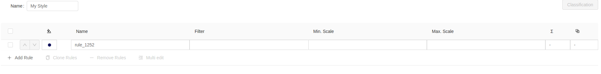
The GeoStyler UI should now match the style that was defined as SLD.
To get the edited style as SLD from the Style component, you can use the writeStyle() method
of the geostyler-sld-parser within the onStyleChange() method of the Style component.
parser.readStyle('<?xml version="1.0" encoding="UTF-8"?>' +
                    '<sld:StyledLayerDescriptor xmlns:sld="http://www.opengis.net/sld" xmlns="http://www.opengis.net/sld" xmlns:gml="http://www.opengis.net/gml" xmlns:ogc="http://www.opengis.net/ogc" version="1.0.0">' +
                        '<sld:NamedLayer>' +
                            '<sld:Name>Default Styler</sld:Name>' +
                            '<sld:UserStyle>' +
                                '<sld:Name>Default Styler</sld:Name>' +
                                '<sld:Title>Gravel_Program_2016</sld:Title>' +
                                '<sld:FeatureTypeStyle>' +
                                    '<sld:Name>name</sld:Name>' +
                                    '<sld:Rule>' +
                                    '<sld:MinScaleDenominator>1.0</sld:MinScaleDenominator>' +
                                    '<sld:MaxScaleDenominator>1.0E7</sld:MaxScaleDenominator>' +
                                    '<sld:LineSymbolizer>' +
                                        '<sld:Stroke>' +
                                            '<sld:CssParameter name="stroke">#8000FF</sld:CssParameter>' +
                                            '<sld:CssParameter name="stroke-width">3.000</sld:CssParameter>' +
                                        '</sld:Stroke>' +
                                    '</sld:LineSymbolizer>' +
                                    '</sld:Rule>' +
                                '</sld:FeatureTypeStyle>' +
                            '</sld:UserStyle>' +
                        '</sld:NamedLayer>' +
                    '</sld:StyledLayerDescriptor>')
    .then(style => this.setStyle({myStyle: style.output}));

// ...

<Style
    compact={true}
    style={myStyle}
    onStyleChange={gsStyle => {
        parser.writeStyle(gsStyle)
            .then(sld => console.log(sld.output));
    }}
/>
Things to try
As a next step, you can try to add an OpenLayers map and connect the Style component to the map,
so that you can directly see the changes you made on the map.
What next?
Check out these other resources about this application.